 DNA-based trend in the distributional range of invasive taxa
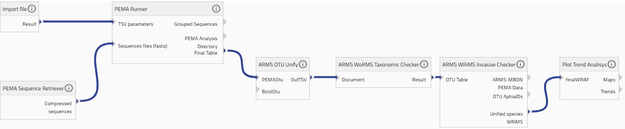
This workflow aims at quantifying the geographic spread of invasive species by using spatial analyses to map their expansion, as it comes from the observations. Starting with the PEMA-derived species list from barcodes, records are filtered to include only recognised invasive taxa. Each occurrence is enriched with the sampling coordinates associated with ARMS deployments, and all points are pooled across temporal and spatial datasets. The Geographic information service , Plot Trend Analysis offered by MyLifeWatch are then used to compute spatial metrics for each invasive taxon. Comparing successive timeframes reveals the direction and magnitude of range expansion. The outputs include maps that demonstrate newly occupied regions
Default
- Date ( Publication)
- 2025-09-01
- Status
- Completed
- Version
-
1.0.0
- Keywords
-
trend
- Keywords
-
invasive species
- Keywords
-
taxonomy
- Keywords
-
PEMA
- Keywords
-
DNA-based
- Keywords
-
ARMS
- Keywords
-
spatial analysis
- Keywords
-
metabarcoding
- Access constraints
- License
- Use limitation
-
GPLv3 - <a href=" https://www.gnu.org/licenses/gpl-3.0.html" target="_blank"> https://www.gnu.org/licenses/gpl-3.0.html</a>
- OnLine resource
-
Link to the workflow
(
WWW:LINK-1.0-http--link
)
- Service Name
-
PEMA Runner
- Service Description
-
This service aims at running PEMA on all the sequences passed as input. It also requires a parameter file (a tsv file).
- Service Reference (id)
- Service Name
-
PEMA Converter
- Service Description
-
This service aims to reformat and produce final output in various formats for human and machine2machine reading.
- Service Reference (id)
- Service Name
-
PEMA Sequences Retriever
- Service Description
-
This service aims to download the sequences files (fasq files) in order to run PEMA.
- Service Reference (id)
- Service Name
-
ARMS OTU Unifier
- Service Description
-
This service aims at creating an OTU table with species information that can be processed by WoRMS and WRIMS.
- Service Reference (id)
- Service Name
-
ARMS WoRMS Taxonomic Checker
- Service Description
-
WoRMS taxon match webservice to check for the WoRMS match.
- Service Reference (id)
- Service Name
-
ARMS WRiMS Invasive Checker
- Service Description
-
WRIMS taxon match webservice to check the known distribution of the species.
- Service Reference (id)
- Service Name
-
Plot Trend Analysis
- Service Description
-
This service allows to monitor and quantify the geographical expansion of invasive species using spatial analysis of metabarcoding data.
- Service Reference (id)
- Workflow Helpdesk
metadataMetadata
- File identifier
- 2c6e37fc-0723-4edf-a48e-fad3bb4e7026 XML
- Metadata language
- en
- Hierarchy level
- Workflow
- Metadata Schema Version
-
1.0
Overviews
Spatial extent
Provided by
