Ailanthus Workflow - Combining Modeling and remote sensing techniques to monitor and control the spread of invasive species:
the case of Ailanthus altissima - v2
Ailanthus Workflow - Combining Modeling and remote sensing techniques to monitor and control the spread of invasive species:
the case of Ailanthus altissima - v2
Background
Ailanthus altissima is one of the worst invasive plants in Europe. It reproduces both by seeds and asexually through root sprouting. The winged seeds can be dispersed by wind, water and machinery, while its robust root system can generate numerous suckers and cloned plants. In this way, Ailanthus altissima typically occurs in very dense clumps, but can also occasionally grow as widely spaced or single stems. This highly invasive plant can colonise a wide range of anthropogenic and natural sites, from stony and sterile soils to rich alluvial bottoms. Due to its vigour, rapid growth, tolerance, adaptability and lack of natural enemies, it spreads spontaneously, out-competing other plants and inhibiting their growth
Introduction
Over the last few decades, Ailanthus altissima has quickly spread in the Alta Murgia National Park (Southern Italy) which is mostly characterized by dry grassland and pseudo-steppe, wide-open spaces with low vegetation, which are very vulnerable to invasion. Ailanthus altissima causes serious direct and indirect damages to ecosystems, replacing and altering communities that have great conservation value, producing severe ecological, environmental and economic effects, and causing natural habitat loss and degradation. The spread of Ailanthus altissima is likely to increase in the future, unless robust action is taken at all levels to control its expansion. In a recent working document of the European Commission, it was found that the cost of controlling and eliminating invasive species in Europe amounts to euro 12 billion per year. Two relevant questions then arise: i) whether it is possible or not to fully eradicate or, at least, to reduce the impact of an invasive species and ii) how to achieve this at a minimum cost, in terms of both environmental damage and economic resources.
A Life Program funded the Life Alta Murgia project (LIFE12BIO/IT/000213) had, as its main objective, the eradication of this invasive exotic tree species from the Alta Murgia National Park. That project provided both the expert knowledge and valuable in-field data for the Ailanthus validation case study, which was conceived and developed within the Internal Joint Initiative of LifeWatch ERIC.
Aims
At the start of the on-going eradication program a single map of A. altissima was available, dating back to 2012. Due to the lack of data, predicting the extent of invasion and its impacts was extremely difficult, making it impossible to assess the efficacy of control measures. Static models based on statistics cannot predict spatial–temporal dynamics (e.g. where and when A. altissima may repopulate an area), whereas mechanistic models incorporating the growth and spread of a plant would require precise parametrisation, which was extremely difficult with the scarce information available. To overcome these limitations, a relatively simple mechanistic model has been developed, a diffusion model, which is validated against the current spatial distribution of the plant estimated by satellite images. This model accounts for the effect of eradication programs by using a reaction term to estimate the uncertainty of the prediction. This model provides an automatic tool to estimate a-priori the effectiveness of a planned control action under temporal and budget constraints.
This robust tool can be easily applied to other geographical areas and, potentially, to different species.<div><br></div><div>NOTE: this is the version 2 of the original workflow available at: <a href=" https://metadatacatalogue.lifewatch.eu/srv/eng/catalog.search#/metadata/66744693-cfc7-4901-9838-618e18bb17af" target="_blank"> https://metadatacatalogue.lifewatch.eu/srv/eng/catalog.search#/metadata/66744693-cfc7-4901-9838-618e18bb17af</a>.</div>
Default
- Date ( Publication)
- 2024-07-22
- Status
- Completed
- Keywords
-
Ailanthus
- Keywords
-
IJI
- Access constraints
- License
- Use limitation
-
GPL v3
- OnLine resource
-
Info page
(
WWW:LINK-1.0-http--link
)
- OnLine resource
-
Run the workflow
(
WWW:LINK-1.0-http--link
)
- Service Name
-
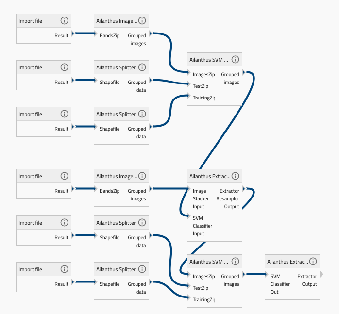
Ailanthus Image Stacker
- Service Description
-
A service that aims at creating a stack of coregistered multi-spectral raster images. It groups four multi-seasons images and stack them to obtain a unique image at native resolution (30 meters) by using the Landsat 5 sensor.
- Service Reference (id)
- Service Name
-
Ailanthus Splitter
- Service Description
-
A service that, starting from a multi-class shapefile containing the land cover classes in the scene, expressed in FAO-LCCS taxonomy, aims to generate a series of shapefiles, one for each different class.
- Service Reference (id)
- Service Name
-
Ailanthus SVM Classifier
- Service Description
-
It is a Support Vector Machine, pixel-based, classifier trained for a multi-class problem.
- Service Reference (id)
- Service Name
-
Ailanthus Extractor Resampler Masking
- Service Description
-
A service that aims at extracting the Deciduous Vegetation Layer from multiclass land cover map at 30 meters, resampling it at 2 meters and masking all the pixels, of the 2 meters stack, not overlaid by the deciduous vegetation layer.
- Service Reference (id)
- Service Name
-
Ailanthus Extractor
- Service Description
-
A service that takes the SVM Classifier result as input to process the data and generate a result and save it under the name extractor_out.zip. It contains Ailanthus map as a result.
- Service Reference (id)
- Workflow Helpdesk
metadataMetadata
- File identifier
- 4f85816a-1653-4e8d-945a-30bbd1faf48f XML
- Metadata language
- en
- Hierarchy level
- Workflow
- Metadata Schema Version
-
1.0