Alvar: Ailanthus altissima visual aid for reconnaissance
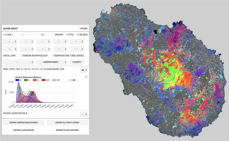
Alvar is a Google Earth Engine cloud application for early reconnaissance of Ailanthus altissima.
Alvar is based on Copernicus Sentinel-2 optical imagery at 10m ground pixel resolution.
The service rationale is that each plant species shows peculiar signals in the optical range and, possibly, time-series signatures. Hence, recognising the invasive alien species A. altissima is in principle feasible, given a characteristic optical spatiotemporal signature. However, even if we can have physiological clues, we do not know such a signature.
Alvar supports the search and reconnaissance of A. altissima optical signature exploiting the cloud computing capability of fast time series search of the images and the vegetation-related associated optical indices, without the need for local data download.
Alvar exploits the machine learning algorithms exposed by the Google Earth Engine APIs and trains them by
means of a user-provided training/control set of empirical observations.
The user interface is GUI-based and the intervention on the code consists only in importing the appropriate
training set and tuning the area of interest bounding box accordingly.
Default
- Date ( Publication)
- 2025-11-21
- Status
- Completed
- Version
-
v.1.0
- Keywords
-
e-Service
- Keywords
-
invasive alien species
- Keywords
-
identification
- Keywords
-
Sentinel-2
- Keywords
-
cloud computing
- Keywords
-
environmental monitoring
- Keywords
-
habitat mapping
- Keywords
-
remote sensing
- Access constraints
- License
- Use limitation
-
GNU GPL-3.0
- Other constraints
-
Users must be logged as Google developers in order to use the application.
- OnLine resource
-
Alvar service
(
URL
)
- OnLine resource
-
DOI
(
DOI
)
- Operation name
-
Aalto: Sample training set for Ailanthus altissima visual aid reconnaissance
- Description
-
The Aalto shapefile consists in a set of training and control points to train different classification algorithms provided by Google Engine. The Alvar and Aalto pair is meant to be a minumim working example for training and classifications. Users can operate with their own datasets, following the simple class and type structure of the Aalto file.
- Function
-
The Alvar script produces a map of potential sites infested by the invasive species Ailanthus altissima. This result is computed based on a traning set (Aalto shapefile) containing information about infested / not-infested areas (sampling sites) and a similar control set to assess the accuracy of the classification.
- Related Services
- Topic Category
- Land cover
- Topic Category
- Habitats and biotopes
- Topic Category
- Species distribution
- Service Category
-
data processing
- Service Language
- eng
- Service TRL
- TRL 3 – Experimental proof of concept
- Service Funding
-
The service was developed within the USEit project: https://www.lifewatchitaly.eu/en/pg-related-projects/useit/
- Service Price
-
Free
metadataMetadata
- File identifier
- b0cde5a8-5d07-44c2-9293-cb1316dfd76a XML
- Metadata language
- en
- Hierarchy level
- Service
- Metadata Schema Version
-
1.0