 Wildfire Resilience from Satellite Image Time Series Virtual Lab
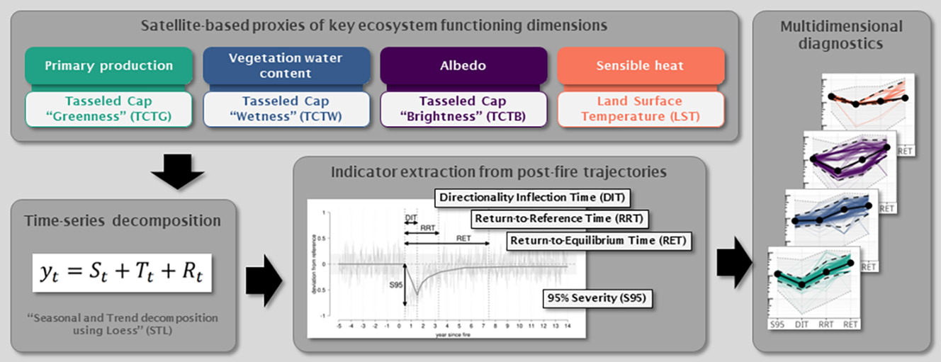
The WiReSITS (Wildfire Resilience from Satellite Image Time Series) Virtual Lab implements a framework published in Marcos et al. 2023 (<a href=" https://doi.org/10.1016/j.rse.2022.113441" target="_blank">DOI: 10.1016/j.rse.2022.113441</a>), for assessing wildfire severity, recovery and resilience, through indicators of changes in ecosystem functioning extracted from satellite image time series. The R-based workflow was improved and updated, from the original code base, to use functions from the "terra" package for pre-processing (filtering amp; smoothing), decomposing (STL), normalizing (versus baseline conditions), and extracting trajectory metrics from satellite image time series (e.g. MODIS).<div>The vLab has been created by using the LifeWatch NaaVRE platform (<a href=" https://naavre.net" target="_blank"> https://naavre.net</a>).</div>
Default
- Date ( Creation)
- 2025-08-05
- Date ( Publication)
- Date ( Revision)
- Status
- Under development / Pre operational
- Keywords
-
Wildfire severity
- Keywords
-
Post-fire recovery
- Keywords
-
Ecosystem functioning
- Keywords
-
Satellite image time series
- Keywords
-
Ecosystem resilience
- Access constraints
- License
- Use limitation
-
Apache License 2.0
- OnLine resource
-
Link to the Virtual Lab
(
WWW:LINK-1.0-http--link
)
- OnLine resource
-
Open NaaVRE
(
WWW:LINK-1.0-http--link
)
metadataMetadata
- File identifier
- 7a5547fb-2eb9-4022-8c00-6703259e3a7f XML
- Metadata language
- en
- Parent identifier
-
NaaVRE - Notebook as a Virtual Research Environment
642002de-0be8-4509-9375-a83ecae395cc
- Hierarchy level
- Virtual Research Environment
- Metadata Schema Version
-
1.0
Overviews
Spatial extent
Provided by
